Measuring the distance to the waypoint


-
Download (0.72 MB)30 March 20221408881309_rrrrsrrrjor-srsssrsrrjos.7z
-
depositfiles.comDownload
I welcome everyone again with my new development - this time with a script.
Although the script is not very useful, it is quite interesting. Have you ever wanted to measure the distance between cities? Or see how long you're going to Grove Street? Now this is possible with this script!
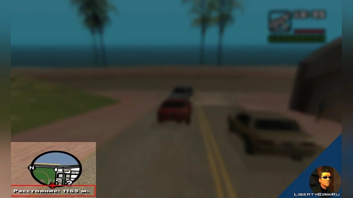
There must be a waypoint on the map. You must be in the car. Press the Num 8 button and the current distance to the waypoint in meters will be displayed under the radar, which will be updated in real time (approximately 20-15 times per second, depending on the performance of the computer).
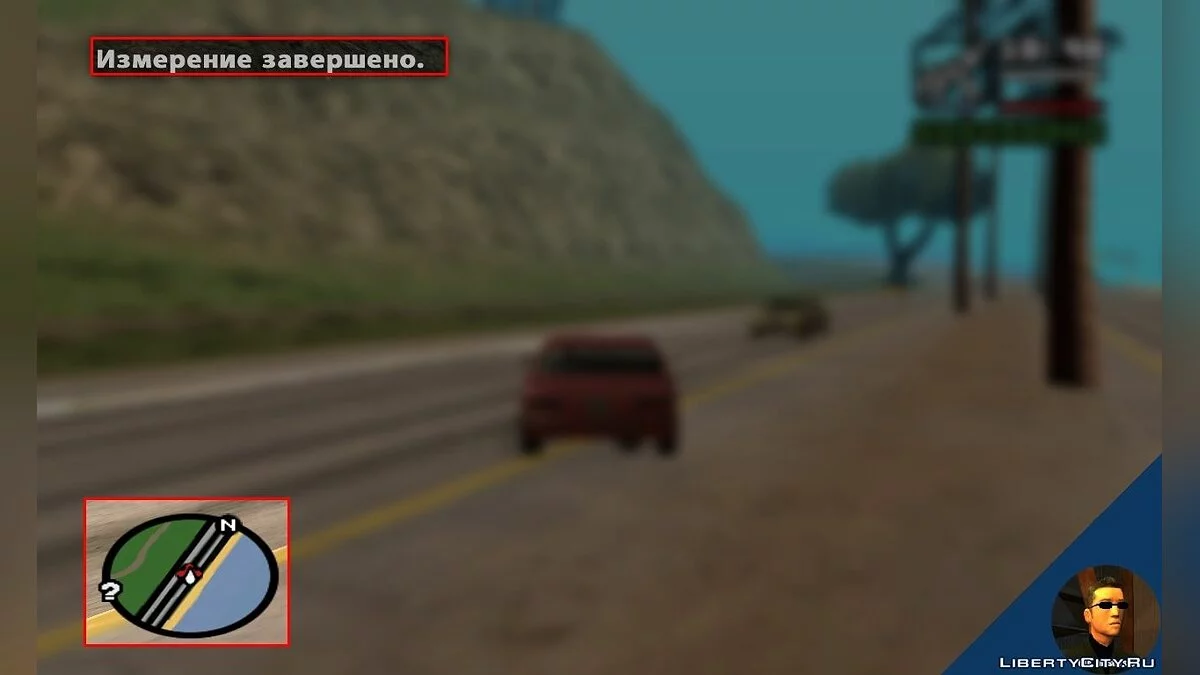
Upon arrival at the place, the measurement will stop, this can also be done manually by pressing Num 9. If you leave the vehicle, the measurement will also be completed.
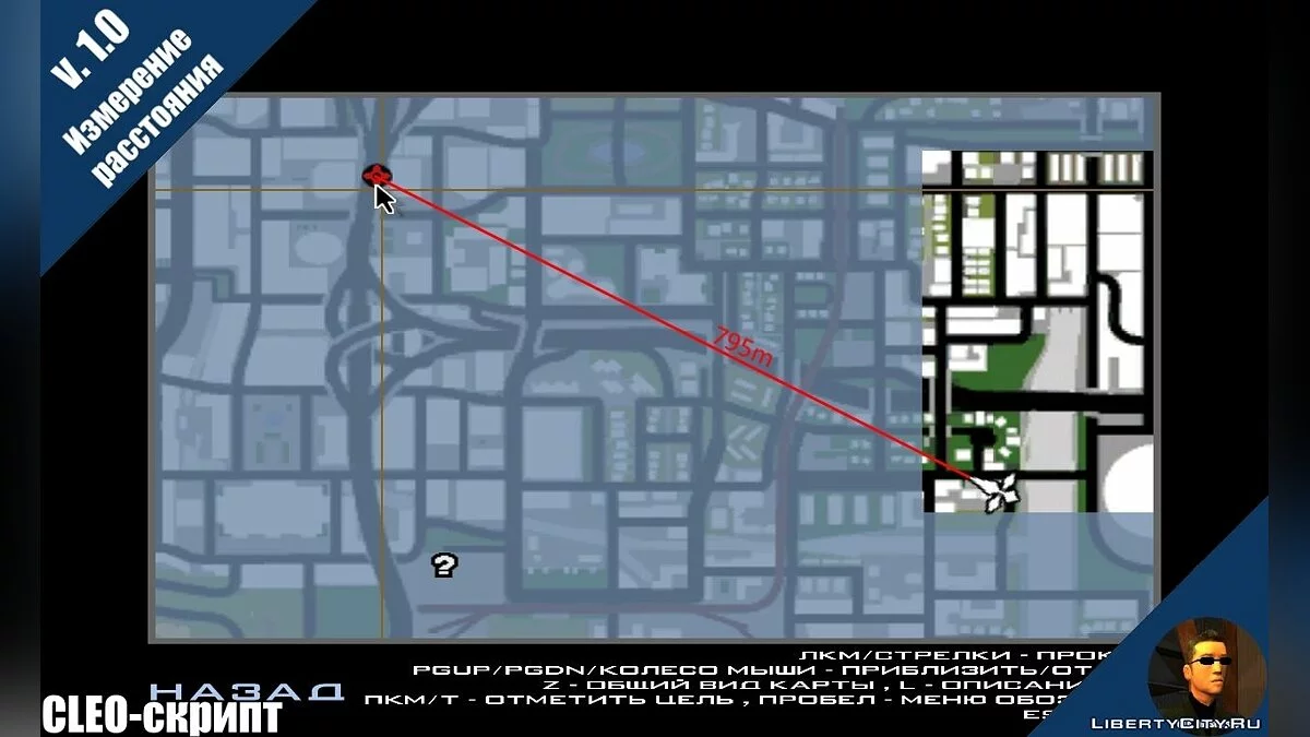
Quote: About mode.txtNuance: the distance is calculated in a straight line (imagine a vector emitted from point A to B, it is clearly visible on the promo), so the distance is NOT calculated along the roads. But this does not interfere much.
[/center]
Tools used to create the mod:
* Sanny Builder 3.2.2 (author - Seamann) [code]
* Paint.NET 4.1 [screenshot processing]
* Bandicam 1.9.5.510 (authors - Bandisoft company) [recording video and taking screenshots]
* Camtasia Studio 8.3 (authors - Techsmith company) [video editing]
* The mod was created and tested on the latest version of CLEO - 4.3.16. Operability is not guaranteed on earlier versions, and especially on CLEO 3. No additional plugins are required for the mod to work. Enjoy the game!
The video is already available for viewing in HD quality.
Support for this mod expires on August 29 (after this date, I will no longer fix bugs and shortcomings - they can be identified earlier).
https://youtu.be/QqlFMlvCN4U
Всех снова приветствую с моей новой разработкой — на этот раз уже со скриптом.
Хоть скрипт и не шибко полезный, но довольно интересный. Вам хотелось когда-нибудь измерить расстояние между городами? Или посмотреть, сколько вы едете до Грув Стрит? Теперь это возможно с этим скриптом!
На карте должен быть вэйпоинт. Вы должны находиться в машине. Нажмите кнопку Num 8 и под радаром будет отображено текущее расстояние до вэйпоинта в метрах, которое будет обновляться в реальном времени (примерно 20-15 раз в секунду, зависит от производительности компьютера).
По приезду на место измерение прекратится, это можно сделать и вручную, нажав Num 9. Если вы покинете транспорт, измерение также будет завершено.
Цитата: О моде.txtНюанс: расстояние рассчитывается прямолинейно (представьте выпускаемый вектор из точки А в Б, на промо хорошо видно), поэтому рассчитывается расстояние НЕ по дорогам. Но это не сильно мешает.
[/center]
Инструменты для создания мода были использованы:
* Sanny Builder 3.2.2 (автор — Seamann) [код]
* Paint.NET 4.1 [обработка скриншотов]
* Bandicam 1.9.5.510 (авторы — компания Bandisoft) [запись ролика и снятие скриншотов]
* Camtasia Studio 8.3 (авторы — компания Techsmith) [монтаж ролика]
* Мод создавался и тестировался на последней версии CLEO — 4.3.16. На более ранних версиях, и тем более на CLEO 3 работоспособность не гарантируется. Дополнительных плагинов для работы мода не требуется. Приятной игры!
Ролик уже доступен для просмотра в HD-качестве.
Срок поддержки этого мода истекает 29 августа (после этой даты я больше не буду исправлять баги и недочеты — их можно выявить и раньше).
https://youtu.be/QqlFMlvCN4U